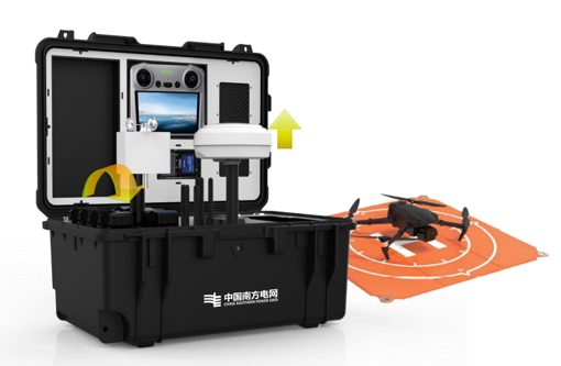
Intelligent Grid Solutions

Powerline Robotics & AI Systems

Modernizing Utility Infrastructure

Universal Aerospace Solutions is dedicated to transforming high-voltage utility grid operations through advanced aerospace engineering, machine learning, and hardware robotics. By developing autonomous airborne hardware and intelligent field systems, we eliminate human exposure to extreme workplace hazards.

We bridge the gap between heavy industrial utility equipment and cutting-edge artificial intelligence, empowering global power grid operators to modernize their structural lifecycle management, optimize network resilience, and execute preventative maintenance seamlessly.

Eliminating High-Voltage Safety Risks

Our primary objective is safety. By deploying mechanized airborne systems for complex tasks—such as line marker ball installations and automated live-line insulator washing—we entirely remove human crews from active hazardous fields and high-voltage failure zones.

Automated Vision Analytics

We maximize operational grid data utility. Our smart computer vision models parse industrial inspection imagery automatically, revealing hidden internal structural degradation, mapping thermal anomalies, and generating immediate, actionable predictive failure analytics.

Autonomous Field Hardware

Robotic Maintenance Platforms

Drone X-Ray NDT

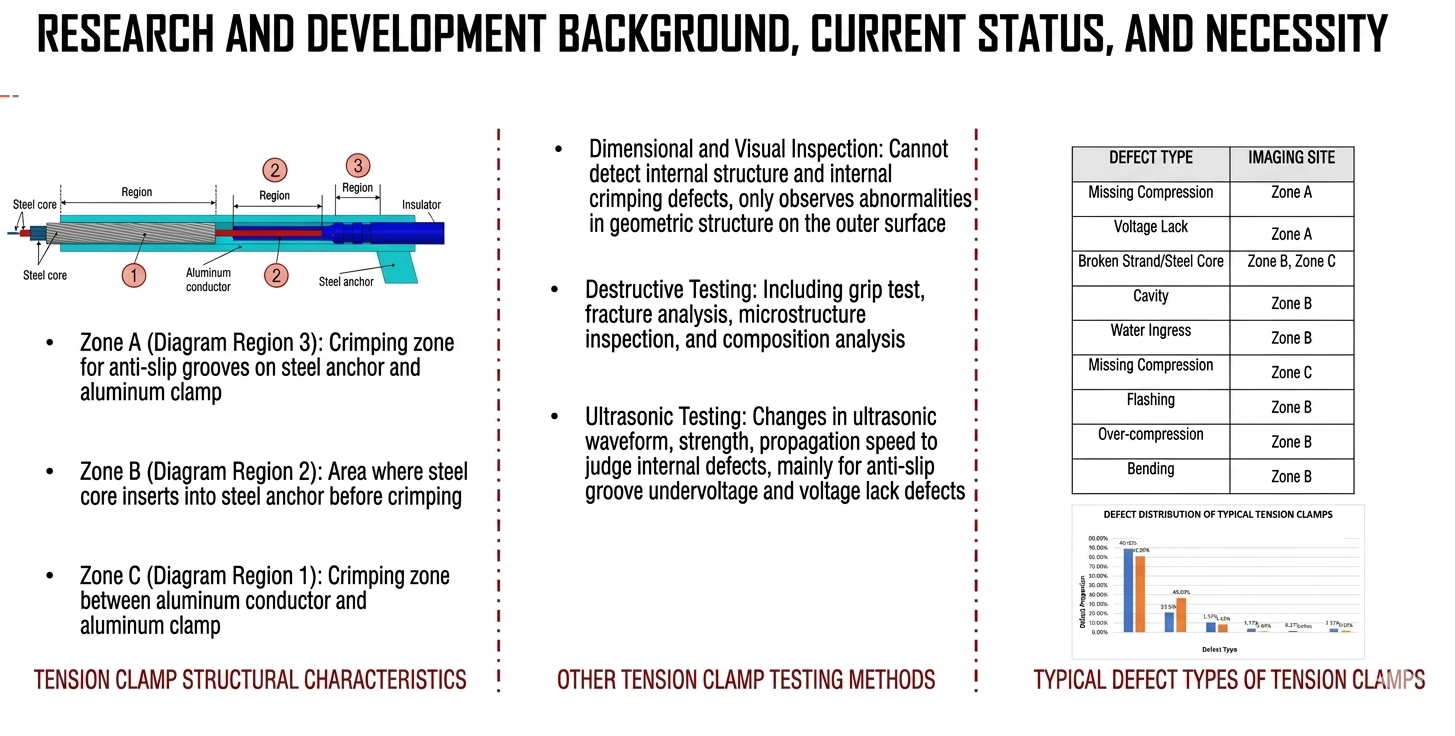
Airborne digital radiographic setups built for non-destructive testing (NDT) across critical overhead line compression joints. They capture deep sub-surface structural alignment, checking crimp integrity and internal steel core voids safely on live power systems.

Insulator Washing Systems

Precision airborne fluid-delivery attachments designed to safely execute automated washing of live high-voltage ceramic and glass insulator strings, preventing pollution flashover risks without line shutdowns.

Marker Ball Installation

Specialized heavy-payload airborne mechanics engineered to lock daytime aerial warning markers securely onto active spans. Eliminates the requirement for human line-crews to work near active conductors.

Integrated Field Engineering Deployment

Our hardware systems provide direct mechanical solutions to back up your custom line-risk profiles. By combining non-destructive drone X-ray imaging with robust maintenance delivery rigs, we bridge heavy electrical grids with autonomous field automation. This allows grid operators to manage and maintain active spans with extreme structural precision.

Multi-Spectral Inspection Core

Drone Inspection & AI Analytics

Universal Aerospace Solutions delivers advanced autonomous drone inspection services powered by centralized deep-learning AI nodes. Our end-to-end framework aggregates high-volume multi-spectral imaging datasets across active powerlines, automatically generating predictive failure matrices and condition audit logs.

Our Multi-Spectral Data Channels:
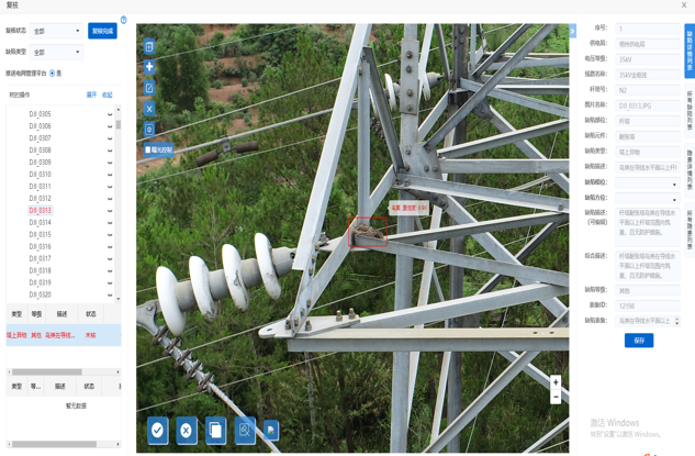
• High-Resolution Visible RGB: Automated object-detection tracking to isolate geometric deformations, broken insulator discs, and structural pylon hardware corrosion.
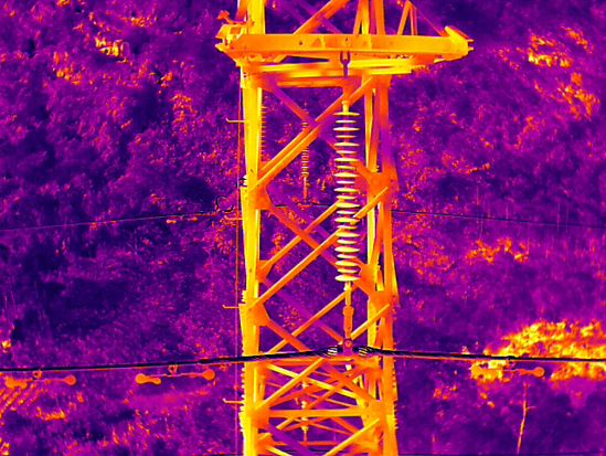
• Infrared Thermal Imagery: Advanced radiometric pixel-matching to pinpoint localized heat differentials, high-resistance connection faults, and baseline substation bushing anomalies.
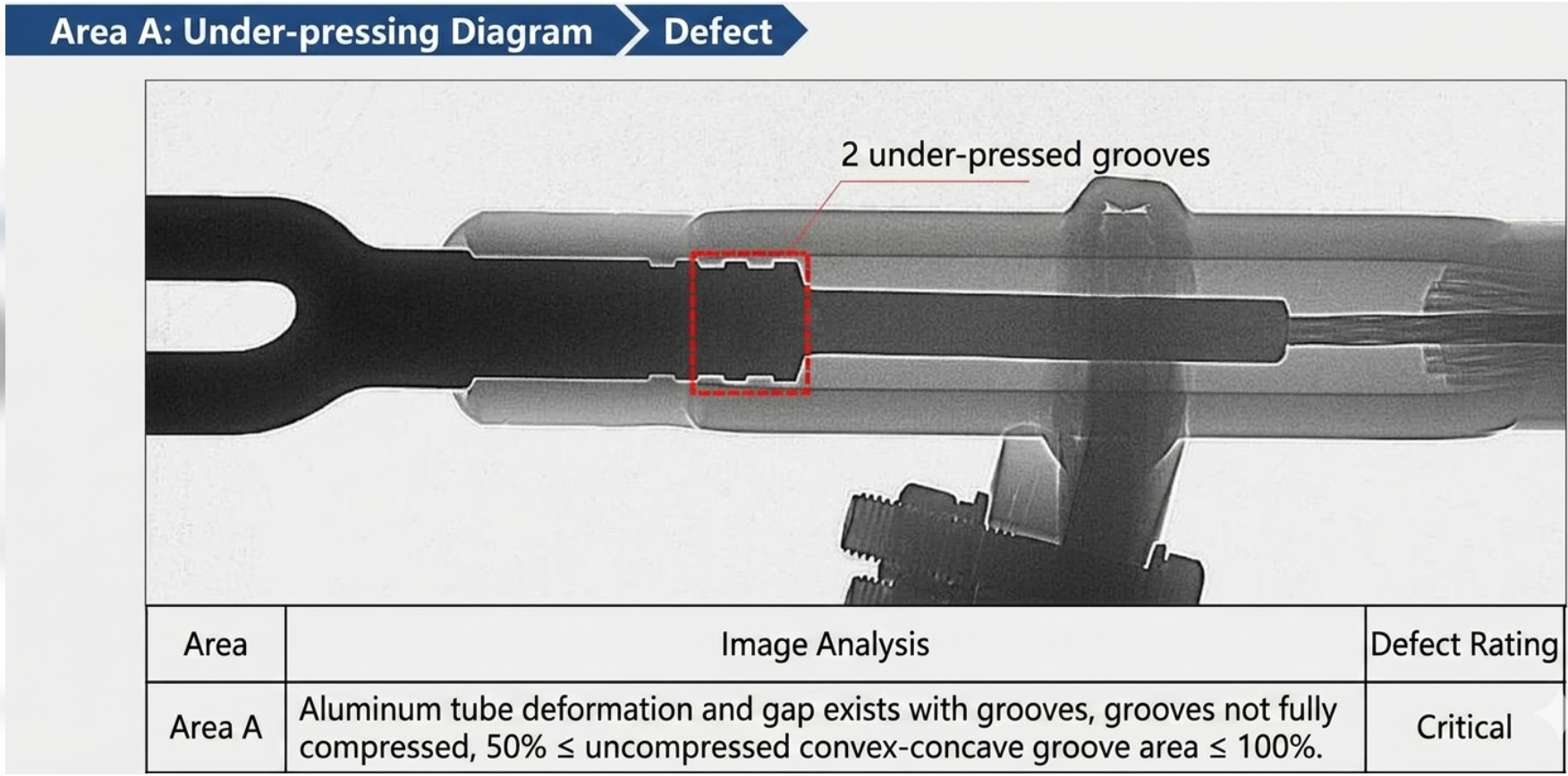
• Non-Destructive X-Ray NDT: Deep radiographic sub-surface data parsing across high-voltage compression joints, mapping internal strand fractures and core wire placement voids.
Visible RGB Inspection
Sample Channel 1: High-Resolution Visible RGB
Infrared Thermal Diagnostics
Sample Channel 2: Radiometric Infrared Thermal
X-Ray Compression Joint NDT
Sample Channel 3: Non-Destructive X-Ray NDT
Analytical Defect Matrix Log
Output Data: Completed X-Ray Analytical Report

End-to-End Enterprise Architecture Routing

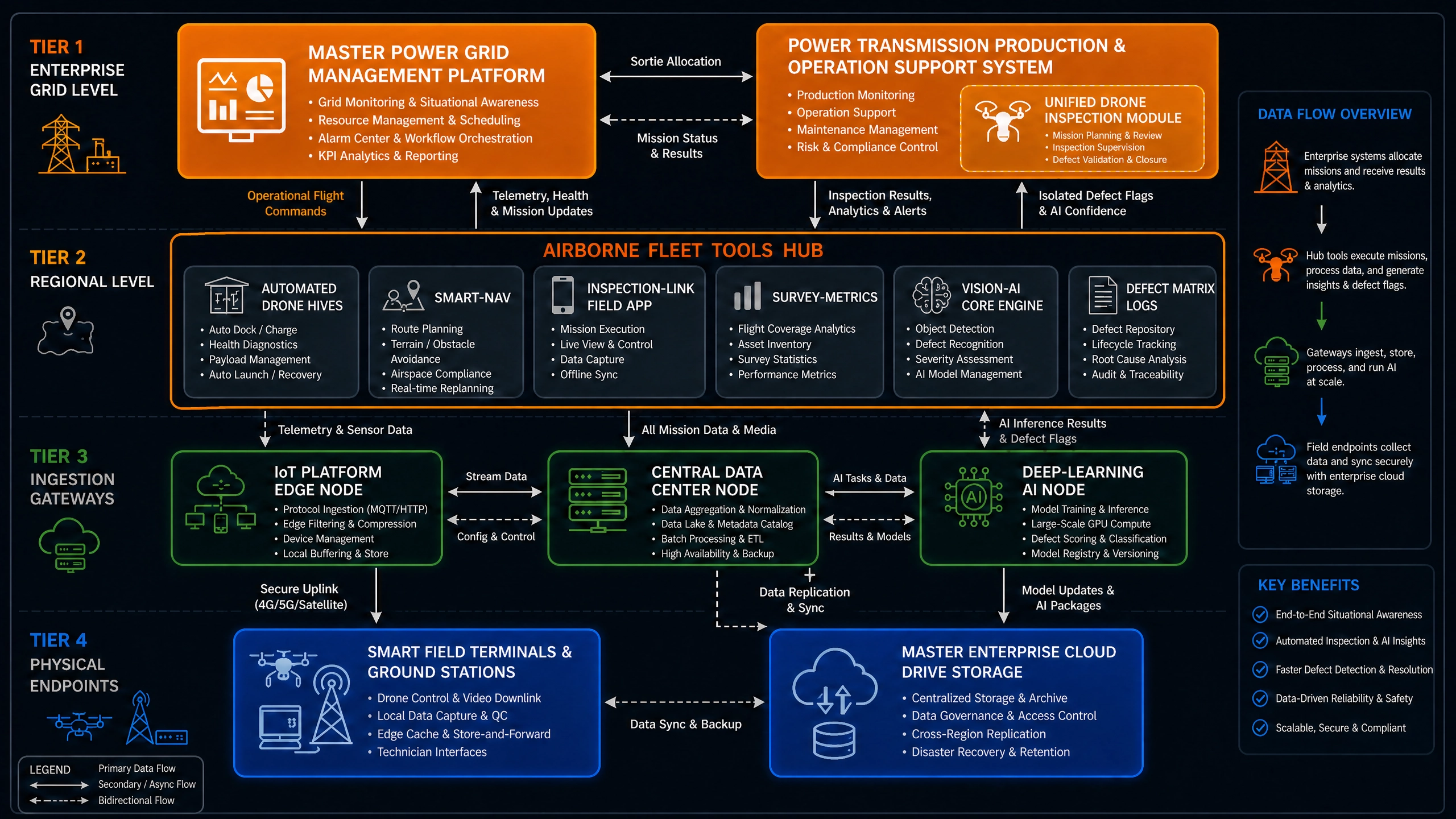
Our multi-spectral inspection data tracks cleanly through a rigorous 4-tier processing tree. Coordinates and field captures upload directly from Smart Field Terminals (Tier 4) into specialized Ingestion Gateways (Tier 3), passing straight through to centralized Deep-Learning AI Nodes to automate structural anomaly mapping. The resulting datasets sync into the Master Grid Management Platforms (Tier 1) automatically, giving utility managers data-justified network maintenance pipelines.
Ecosystem Visual Mapping

System Infrastructure Map

A visual overview of the Universal Aerospace Solutions multi-spectral data stream topology—securely tracking data from ground stations up to centralized master grid platforms.

UAS System Infrastructure and Data Flow Diagram
System Infrastructure Map

Enterprise Data Flow Architecture

Universal Aerospace Solutions operates a ruggedized, multi-tiered software ecosystem that securely binds physical field mechanics with automated enterprise command nodes.

Tier 01

Enterprise Grid Level

Master Management Platform

Consolidated control dashboard driving asset health parameters, dispatch logging, and overarching grid health indexes.

Production & Operation System

Active operations support panel managing live field deployment vectors, resource schedules, and safety mandates.

Tier 02

Regional Level Fleet

Automated Drone Hives

Self-contained remote docking nesting ports for perimeter patrols.

Smart Navigation Modules

Geospatial route guidance loops preventing obstacle field impacts.

Vision-AI Core Engine

Edge computing neural logic filters for real-time item detection.

Inspection-Link Apps

Handheld mobile logs streaming metric tables straight to field engineers.

Tier 03

Ingestion Gateways

IoT Platform Edge Node

Localized pipeline gateway handling ingestion, telemetry parsing, and physical stream synchronization.

Central Data Center

Core computing engine processing bulk file transfers, coordinate verification layers, and asset cross-checks.

Deep-Learning AI Node

Server stack running heavy multi-layer neural model calculations to produce defect matrix logs automatically.

Tier 04

Physical Endpoints

Smart Field Terminals & Ground Stations

Hardware bases tracking active positioning signals, telemetry uplinks, and real-time robotic field adjustments.

Master Enterprise Cloud Drive

Secure, cloud archive storage layers executing long-term historical asset backups and legal compliance record holds.

Tier 04 Physical Hardware

Smart Inspection Endpoints

Providing high-compatibility, fully automated, and ruggedized drone hive systems engineered to execute unmanned industrial workflows across complex topographies.

Fixed Drone Hive Endpoint

1. Fixed Drone Hive

Designed for densely concentrated utility tracking environments, deploying persistent fixed installations to achieve complete automated coverage over regional solar fields and substation arrays.

Technical Performance Metrics:
  • Operational Temperature Range: -30°C to 45°C
  • Native compatibility with UAVX, KML, and KMZ autonomous mission flight paths (channel, precise, and infrared profiles)
  • Supports single-click deployment pushes; drone auto-launches, traverses tracks, and logs asset imagery autonomously
  • Fully human-free automated cycles featuring remote web interface controls and integrated live tracking maps
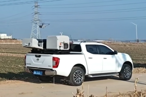
Vehicle-Mounted Drone Hive

2. Vehicle-Mounted Hive

Engineered for widely scattered mountain infrastructure fields and transmission grids, utilizing mobile deployment sweeps to perform periodic field audits.

Technical Performance Metrics:
  • Operational Temperature Range: -30°C to 45°C
  • Native compatibility with UAVX, KML, and KMZ autonomous mission flight paths (channel, precise, and infrared profiles)
  • Supports single-click deployment pushes, remote fleet analytics, and live satellite tracking maps
  • High-Capacity Battery: Built-in 3.6kWh payload support, enabling dual hive array mounting on a single mobile unit.
Capsule Drone Hive

3. Capsule Drone Hive

Engineered specifically to solve data connectivity challenges in extreme, zero-signal topography zones by pairing localized capsule hardware with satellite-based RTK corrections.

Technical Performance Metrics:
  • Compact Footprint: Ultra-portable 551mm * 351mm * 240mm geometry
  • Flexible Power Matrix: Powered via 220V mains infrastructure or direct hot-swappable aircraft battery cells
  • Native compatibility with UAVX, KML, and KMZ autonomous mission flight paths (channel, precise, and infrared profiles)
  • Cloud-linked tracking loops generating real-time hardware status values and live mapping tracking coordinates

Edge-to-Cloud Hardware Integration

All telemetry data, multi-spectral inspection files, and high-precision RTK positional vectors processed by these terminal drone hives stream smoothly through our IoT Edge Nodes (Tier 3). This directly triggers our Deep-Learning AI platforms to map grid anomalies, populate defect matrix files, and automatically sync up with your main grid management software (Tier 1).